

Abstract
Unintended releases from industrial facilities can expose fenceline communities to hazardous substances, and distance between facilities and nearby residential development can play a role in preventing exposures. Here, we assess trends in fenceline community sociodemographic characteristics, land development, and the association between the two using sociodemographic data for census tracts (n = 34 068) surrounding 2457 petroleum refining and chemical manufacturing facilities between 2001 and 2019. We find a higher median growth in percentage of Latinx populations among fenceline communities compared to neighboring communities with no industrial facilities. The increase in the median percentage of Latinx populations within fenceline communities was six times higher than for White populations overall (+6 and +1 percentage points, respectively). Though the percentage of the Black populations did not change within fenceline communities over this period, we find a minor sustained higher percentage of Black residents within fenceline communities relative to neighboring communities (20% versus 19%, respectively). Employing a spatial autoregressive model with autoregressive disturbances, we find that an increase in community percentage Latinx population is associated with a decrease in the rate of land development. Comparing fenceline and neighboring communities, we conclude that Black and Latinx populations are disproportionately located near industrial facilities, potentially contributing to inequitable exposure to unintended chemical releases. Our work lends support to the value of considering of sociodemographic composition of fenceline communities when evaluating industrial facility hazards.
Export citation and abstract BibTeX RIS

Original content from this work may be used under the terms of the Creative Commons Attribution 4.0 license. Any further distribution of this work must maintain attribution to the author(s) and the title of the work, journal citation and DOI.
1. Introduction
Residential proximity to industrial facilities potentially places fenceline communities at risk in the event of an unintended release of hazardous substances. Land use may play a role in preventing environmental exposures [1, 2] in part by providing a buffer between communities and a facility in the event of a release. Accordingly, buffers of undeveloped land between a hazard and potential exposure are a hazard mitigation technique employed by the pipeline [3] and oil and gas extraction industries [4]. Despite the potential hazard of developed land near industrial facilities, to our knowledge few studies have examined changes to land use within the context of industrial facilities [5].
Community proximity to an industrial facility is a crude proxy for risk to communities were an unintended release at a facility to occur, though analysis of proximity is still important regardless of the size and frequency of the release. Analysis of incidents investigated by the U.S. Chemical Safety Board (CSB) finds incidents commonly involved impacts to the community [6] resulting, in part, from facility and community proximity [7]. Communities living in close proximity to these hazardous industrial facilities are disproportionately comprised of historically marginalized populations [8–10], owing in part to zoning of areas for industrial use near historically marginalized communities [2, 11–14]. Evidence of the disproportionate co-location of historically marginalized populations and hazardous waste was first demonstrated by environmental justice scholarship over 30 years ago [15], though despite growing attention, the distribution of environmental hazards has become increasingly inequitable [8]. Prior studies of sociodemographic characteristics of fenceline communities have typically been cross-sectional or conducted on a small geographic extent, assessing neither national nor temporal trends [16]. Temporal information on sociodemographic characteristics of fenceline community is needed to understand if potential exposures to historically marginalized groups have been mitigated or exacerbated over time.
Temporal information is also important as a bi-directional relationship exists between land development and population growth [17, 18]. Population growth encourages land development for uses to support increasing populations (i.e. housing), while land development attracts population growth through economic opportunities. Only one study has examined nationwide land development in the context of inequality by examining trends in census tract sociodemographic characteristics and land development between 2001 and 2011 [19]. The authors aimed to describe the degree to which the rate of land development changes based on sociodemographic changes, finding that a decrease in privileged populations is negatively associated with the rate of land development. The authors examined land development not as an environmental exposure, but rather, as a 'mundane' driver of environmental inequality. Here, we examine land development as a largely permanent transformation of the built environment rather than specific environmental impacts.
In this study, we examine: (1) trends in fenceline community characteristics compared to neighboring communities, as well as among communities with greater potential exposure; and (2) the degree to which sociodemographic changes are associated with changes in developed land. We hypothesize that: (1) the percentage of historically marginalized populations has increased within fenceline communities compared to neighboring communities, and that these trends are exacerbated within communities with greater potential exposure; and (2) an increase in the percentage of privileged populations is associated with a decrease in land development. By describing trends in the sociodemographic characteristics of fenceline communities as well as simultaneous change in land development, we aim to ascertain the extent to which potential exposures to historically marginalized groups has been mitigated or exacerbated over time.
2. Methods
Our conceptual framework (figure 1) begins with industrial facility siting and location. Studies demonstrate that demographic composition of communities can influence where facilities are built and demographic changes can occur in response to new industrial development [10, 20]. Based on this prior literature, we assume a bi-directional relationship between facility siting and community sociodemographic characteristics, illustrated by the first vertical row in the conceptual framework ('industrial facility siting'). The following sections describe parameters in the conceptual framework and the methods used to test each of the hypotheses (second vertical row in the framework, 'sociodemographic changes' and 'land development').
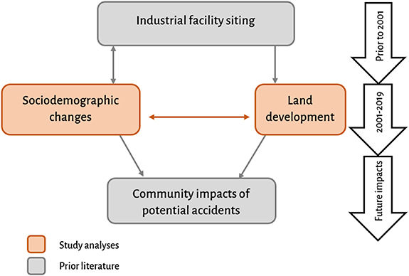
Figure 1. Conceptual framework for the relationship between sociodemographic changes and land development within fenceline communities. Orange boxes represent the hypotheses tested in the present study while grey boxes represent assumptions from prior literature.
Download figure:
Standard image High-resolution image2.1. Hazardous facilities
We define industrial facilities as those using hazardous substances in 10 high-hazard North American Industry Classification System (NAICS) codes, including pulp mills, petroleum refineries, and chemical manufacturing, reporting to the Toxics Release Inventory (TRI) maintained by the US Environmental Protection Agency (EPA) (figure S1) (www.epa.gov/toxics-release-inventory-tri-program/tri-basic-data-files-calendar-years-1987-present, accessed 24 June 2023). We select this subset of hazardous facilities as facilities in these NAICS with processes using threshold quantities of hazardous substances and are subject to the EPA's risk management plan rule (RMP). Between 2001 and 2019, 2457 unique facilities in our included industries reported to the TRI. The majority of these facilities in 2019 were chemical manufacturing facilities (88%, n = 2167), followed by petroleum refineries (9%, n = 213) and pulp mills (3%, n = 77). The facilities are located in 49 states and two US territories, with 20% of facilities located in Texas (n = 235) and 7% in Louisiana (n = 86) in 2019 (n = 1080) (table S1). We present results at the national level as the EPA's RMP program requirements apply nationally.
2.2. Changes in community sociodemographic characteristics
We first compare trends in fenceline and neighboring community sociodemographic characteristics to test the hypothesis that the percentage of historically marginalized fenceline populations has increased between 2001 and 2019 compared to neighboring communities with no industrial facilities. A time period of 2001–2019 and the census tract geographic unit was selected as these years are available across all input datasets. We define a fenceline community as within a 5 km circular buffer of included industrial facilities, as buffers greater than 3 km have been demonstrated as necessary in preserving characteristics of the fenceline community beyond the immediate facility fenceline [9]. We select a local comparison group (an additional 5 km buffer beyond the facility (5–10 km)), rather than state or national comparisons, to assess differences between fenceline communities and neighboring communities [21]. We employ a series of aggregation methods to avoid the unit-hazard coincidence and reduce the modifiable areal unit problem (figure S2) [9, 22, 23]. We calculate change as the difference in census tract sociodemographic percentage for 2019 less 2001 (2019–2001), rather than percent change ([(2019–2001)/2001]), as a small increase in population among less-populated subgroups can result in a large percentage change, challenging interpretability. Similarly, we present results as the change in the median census tract percentage rather than the means to avoid the influence of outliers.
We extract census tract level data on race, ethnicity, educational attainment, poverty status, linguistic isolation, and female headed households using both decennial Census data and the American Community Survey (ACS) estimates. We apply 2000 U.S. Census data to the years 2001 and 2004, the 2010–2014 ACS to the years 2006, 2008 and 2013, and the 2015–2019 ACS to the years 2016 and 2019 [24] (table S2). Examination of longitudinal trends between spatially varying census tracts is enabled by the Longitudinal Tract Database cross walk tables [25] which employ population and areal weighting to apportion 2000 census-tract boundaries to the 2010 census boundaries.
For our indicators of privilege, we include White race and educational attainment greater than a high school education. We develop a working definition of 'historically marginalized populations' to include ethnicity of Hispanic or Latino origin (Latinx) within all racial groups, racial groups of Black (Black and African American) and other non-white (American Indian, or Alaska Native, Asian, Native Hawaiian or Other Pacific Islander, two or more races, and some other race), as well as persons with less than or equal to one ratio of income to poverty (poverty threshold) in the last 12 months. We also include in our definition the proportion of female headed households, which was found to be significant in a prior study of air toxics [26].
We assess sociodemographic trends by varying sources of potential exposure. First, we assess the difference in sociodemographic trends between facilities reporting greater than the 75th percentile of annual total onsite releases of hazardous substances (>2300 pound) and less than or equal to the 75th percentile. We next calculate the number of facilities within a 5 km radius of census tract centroids and compare sociodemographic changes within communities with more than one facility as compared to those with one facility. Finally, as a surrogate for 'new' facilities, we assess sociodemographic changes in communities surrounding facilities reporting for the first time after 2001 as compared to facilities reporting in 2001 or earlier. We hypothesize that increases in the percentage of historically marginalized fenceline populations is greater among communities with a greater volume of annual releases, more than one industrial facility, and near facilities reporting for the first time after 2001.
2.3. Association between fenceline community land development and sociodemographic changes
We next examine the association between land development and fenceline community sociodemographic characteristics, assuming a concurrent and bi-directional relationship. We hypothesize that more privileged populations have decreased within fenceline communities and that these decreases are associated with increases in the rate of land development.
We quantify change in land development surrounding included industrial facilities by quantifying the census tract level change (2019–2001) in total square kilometers (km2) of developed land within fenceline communities compared to neighboring communities. We employ the National Land Cover Database (NLCD), a nationwide land cover classification database with a high resolution for the years 2001 and 2019 (figure S3). Developed by the US Geological Survey, the NLCD is available at 30 m × 30 m gridded resolution and applies a decision-tree raster classification of six Landsat bands to classify images into 20 land use types [27]. We create a new binary raster dataset by categorizing all developed types together as well as all undeveloped land types together. We lose some spatial heterogeneity by reprojecting the 30 m2 gridded estimates to 1 km2 to maximize computational efficiency.
Similar to Clement and Alvarez (2020), we conduct a spatial autoregressive model with autoregressive disturbances (SARAR), modeling the association between the change between 2001 and 2019 in developed land (km2) per census tract (dependent variable) and the change in census tract percentage of included sociodemographic characteristics (independent variables). The SARAR model accounts for spatial autocorrelation in the dependent variable (lag) and error term, where  represents the change in the dependent variable (developed land (km2)) for census tract
  between 2001 and 2019
  ;
;  represents the change,
  , in the percentage of the independent variables,
  , for census tract
  and
and  represents the effect of each independent variable
  (equation (1)). We log-transform and difference our dependent and independent variables to create a change score for each variable accounting for the change between 2001 and 2019, adding a constant of '1' to correct for zero-values when log-transforming and interpreting the slope estimates as elasticities. When using two periods of data, first differencing facilitates longitudinal analysis because it controls for time-invariant characteristics of the unit of analysis, i.e. census tracts.
Owing to multicollinearity among included sociodemographic variables (table S3), we include as our independent variables ( ) the log-transformed, differenced (i.e. percentage in 2019 less the percentage in 2001) change score in the percentage White, greater than high school education, Latinx, and below the poverty threshold. We also include several control variables including the count of facilities within 5 km (
 ), the log-transformed, change in total census tract population (
 ), total census tract area (km2,
  ) and total population and total subgroup population (
 in 2001. Representing the spatial lag,
  denotes the lag term of the weighted average of the dependent variable for each census tract based on the spatial weight
  for that census tract, established using first-order queen contiguity. The error term
  is comprised of spatial error term
  , also calculated using the weights matrix
  , as well as the terms
  .
.
Equation 1. SARAR Model,
In addition to our main model described above, we assess the relationship between the change in community sociodemographic characteristics and land development for census tracts with available spatial information on historical segregation, described in the supplemental material.
3. Results
3.1. Trends in fenceline community sociodemographic characteristics and developed land
We find the total population living within fenceline (<5 km) communities decreased 48% between 2001 and 2019 (85 million surrounding 1841 facilities in 2001 versus 44 million surrounding 1080 facilities in 2019); a greater degree than observed in neighboring communities (5–10 km) (33%: 117–78 million) (table S4). Among historically marginalized populations, we observe the largest increase among Latinx fenceline populations (22% in 2001–28% in 2019) (table S4 and figure 2). Developed land increased modestly within industrial facility fenceline communities (59 600 per 1841 facilities to 47 300 km2 per 1080 facilities), less than the change in developed land in neighboring communities (69 600–72 900 km2).
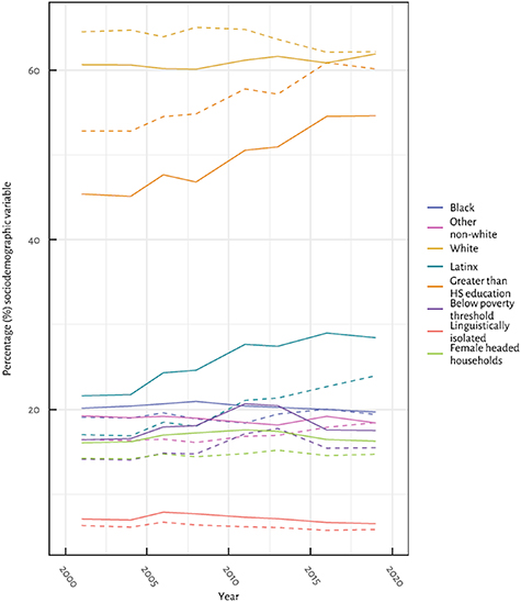
Figure 2. Trends in sociodemographic composition of fenceline communities (<5 km; solid lines) and neighboring communities with no included industrial facilities (5–10 km; dashed lines) between 2001 and 2019.
Download figure:
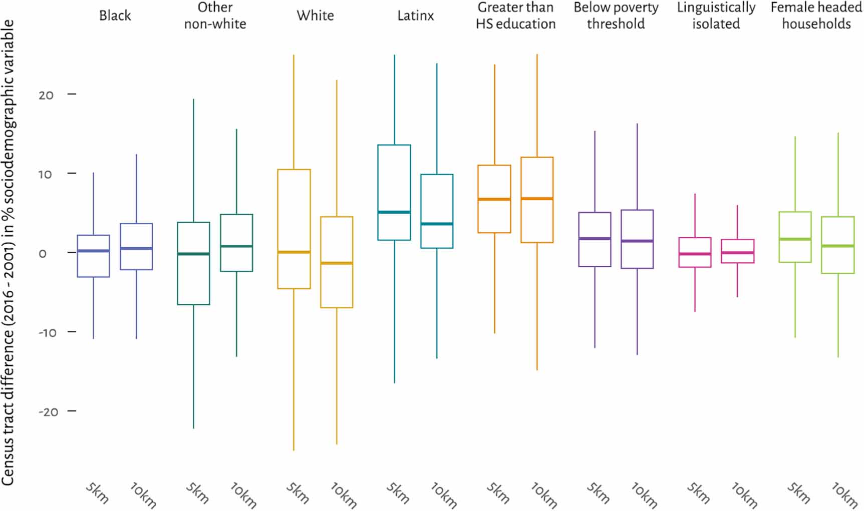
Standard image High-resolution imageComparing median census tract level change (2019–2001) in sociodemographic percentages (table 1 and figure 3), we find that Latinx, below the poverty threshold and female headed household population categories grew more within fenceline communities compared to neighboring communities (Latinx = +6% vs. +4%, respectively; female headed households = +2% vs. 1%; below the poverty threshold = +2% vs. +1%). White populations increased within fenceline compared to a decrease in neighboring communities (+12% and −1%, respectively). The change in median census tract percentages was the same within both fenceline and neighboring communities for Black, other non-white, greater than high school education, below the poverty threshold and linguistically isolated populations. Though the percentage of the Black populations did not change within fenceline communities over this time period, we find a minor sustained higher percentage of Black residents within fenceline communities relative to neighboring communities (20% versus 19%, respectively) (table S4). We note that our results intend only to compare fenceline communities to their immediate neighboring communities and are not necessarily independent of national trends.
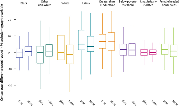
Figure 3. Change (2019–2001) in population percentage (%) sociodemographic characteristics within fenceline (<5 km) and neighboring communities (5–10 km). HS = high school. Extents of the boxplot represent the interquartile range (25th–75th percentile) with the middle line representing the median value.
Download figure:
Standard image High-resolution imageTable 1. Median census tract population percentage (%) for 2001, 2019, and the median census tract change (2019–2001) in population percentage (%) within fenceline communities (<5 km) and neighboring communities (5–10 km). HS = high school.
| Variable | Median (IQR) 2001 | Median (IQR) 2019 | Median change (IQR) (2019–2001) | |||
|---|---|---|---|---|---|---|
| Fenceline census tracts (<5 km) | Neighboring census tracts (5–10 km) | Fenceline census tracts (<5 km) | Neighboring census tracts (5–10 km) | Fenceline census tracts (<5 km) | Neighboring census tracts (5–10 km) | |
| Black | 6 (2–21) | 7 (2–31) | 5 (2–21) | 10 (3–30) | 0 (−3–2) | 1 (−2–4) |
| Other non-white | 11 (4–24) | 8 (3–22) | 8 (5–16) | 9 (4–18) | 0 (−9–4) | 1 (−3–5) |
| White | 74 (46–87) | 74 (43–89) | 79 (50–91) | 72 (48–86) | 1 (−5–15) | −1 (−8–6) |
| Latinx | 13 (3–32) | 6 (2–20) | 29 (7–46) | 11 (3–36) | 6 (2–16) | 4 (1–11) |
| Greater than HS education | 39 (29–54) | 48 (34–68) | 49 (39–62) | 57 (43–74) | 7 (3–11) | 7 (1–13) |
| Below the poverty threshold | 12 (6–22) | 11 (5–21) | 15 (7–23) | 13 (6–24) | 2 (−2–5) | 1 (−2–5) |
| Linguistically isolated | 3 (1–9) | 2 (1–6) | 3 (1–9) | 2 (1–8) | 0 (−2–2) | 0 (−1–2) |
| Female headed household | 12 (9–18) | 11 (8–19) | 14 (9–21) | 13 (8–21) | 2 (−1 to 5) | 1 (−3 to 5) |
a Note: Median change (2019–2001) in percentage represents the median change across all census tracts and does not equal the difference between the median columns presented in this table for 2001 and 2019.
We observe fluctuation in the total annual releases reported by facilities. In 2001, a total of 543.7 million pounds of hazardous substances were released from 1841 facilities (table S5), while in 2019, 298.8 million pounds were released from 1080 facilities. We next compare fenceline community sociodemographic composition between 2001 and 2019 surrounding facilities reporting greater than the 75th percentile of total annual onsite releases (>2300 pounds), to facilities with less than or equal to the 75th percentile total annual onsite releases (≤2300 pounds). We observe minimal difference (±2%) for greater than high school education, below the poverty threshold, linguistically isolated, female headed households, and other non-white populations (table S6 and figure S4). White populations decreased (−4%) and Black populations increased (+4%) surrounding facilities with greater than the 75th percentile of total onsite releases. Latinx populations increased surrounding facilities with less than the 75th percentile releases as compared to those with greater than the 75th percentile (+9% vs. +3%, respectively), while Black populations decreased surrounding facilities with less than the 75th percentile total onsite releases (−3%). We observe regional differences across US EPA federal regions, including an increase in the percentage of historically marginalized fenceline communities within Regions 3 and 5, and a decrease in Region 7 (figure S5, table S7).
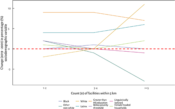
We observe a positive association between increasing facility count and the median census tract change (2019–2001) in percentage of Latinx, female headed households, White, and greater than high school education population subgroups, as well as an inverse association for other non-white populations (figure 4 and table S8). Black, below the poverty threshold, and linguistically isolated population categories had limited or no difference. Increases in Latinx populations from 2001 to 2019 were amplified for communities in the top quartile of the number of nearby facilities (5–32 facilities; +6 percentage points) compared to communities with only one to two facilities nearby (+4 percentage points). Within communities with the third highest quartile (3–4 facilities), the change in Latinx populations was four times higher than White populations (+4% and no change, respectively) (table S8). We observe several non-linear trends between increasing facility count and percentage sociodemographic composition (e.g. the decrease and then subsequent increase for Black populations).
Figure 4. Median change (2019–2001) in population percentage (%) sociodemographic characteristics within fenceline community census tracts by quartile of the count (n) of facilities within 5 km of census tract centroids.
Download figure:
Standard image High-resolution image
Total count of facilities varied over the study period, with 431 (18%) facilities reporting for the first time after 2001 and 1010 (41%) facilities that reported in 2001 discontinuing reported before 2019. We observe minimal change (less then ±2 percentage points) in sociodemographic composition between facilities that first reported after 2001 as compared to those that reported in 2001 or earlier for Black, White, below the poverty threshold, linguistically isolated and female headed households (figure S6 and table S9). The percentage of other non-white populations increased modestly surrounding new facilities as compared to existing ones (+4% and +1% respectively), while the percentage of Latinx populations increased at a rate 1.5 times higher surrounding new facilities as compared to existing facilities (+12% and +7% respectively). We also find that the percentage of populations with greater than a high school education increased at a slower pace surrounding new facilities as compared to existing facilities (+4% as compared to +9% respectively).
3.2. Association between fenceline community land development and sociodemographic changes
We next examine the relationship between the change in developed land (km2) per census tract within fenceline communities (n = 15 991) and the change in percentage of included sociodemographic variables (White, greater than high school education, Latinx ethnicity and below the poverty threshold). We find a negative, insignificant relationship between change in percentage White and below the poverty threshold, a negative significant relationship between change in percentage Latinx populations, as well as a positive, insignificant relationship between change in percentage greater than high school education and change in land development (table 2). In other words, census tracts that experienced an increase in the percentage Latinx populations experienced a lower rate of land development. Results for the analysis by HOLC neighborhoods is presented in table S10.
Table 2. Results for the spatial autoregressive with autoregressive disturbances (SARAR) models of the association between the change between 2001 and 2019 in developed land (km2) per census tract and the change in census tract percentage of included sociodemographic characteristics.
| Fenceline census tract sociodemographic variables | Change in developed land per census tract area (km2) for fenceline (<5 km) communities | |
|---|---|---|
| (n census tracts = 15 991) | ||
| β | SE | |
| Independent variables (Δ between 2001 and 2019) | ||
| Percentage White | −0.063 | 0.050 |
| Percentage greater than high school education | 0.042 | 0.071 |
| Percentage Latinx | −0.279* | 0.063 |
| Percentage below the poverty threshold | −0.109 | 0.064 |
| Controls (Δ between 2001 and 2019) | ||
| Change in total population | 0.296 | 0.011 |
| Controls (time invariant) | ||
| Count of facilities within 5 km of census tract centroid in 2001 | −0.013* | 0.003 |
| Total population in 2001 | 0.000* | 0.000 |
| Total White population in 2001 | −0.000* | 0.000 |
| Total population with greater than high school education in 2001 | 0.000* | 0.000 |
| Total Latinx population in 2001 | −0.000* | 0.000 |
| Total below the poverty threshold | −0.000 | 0.000 |
| Total census tract area (km2) | 0.137* | 0.003 |

| 0.004 | 0.021 |

| 0.010 | 0.003 |
Independent variables have been log-transformed and first-differenced, representing the change score between 2001 and 2019. All control variables aside from number of facilities and total census tract area have been log-transformed. β = beta coefficient; SE = standard error;  = spatial lag parameter;
  = spatial error parameter; * = p < 0.05.
4. Discussion
In this study, we demonstrate sociodemographic changes within communities in close proximity to hazardous industrial facilities nationwide, building upon prior cross-sectional and subnational studies for a subset of these facilities. We observe that the median increase in the proportion of fenceline Latinx populations was six times higher than that of Whites (+6% and +1%, respectively). We find minimal change in the median percentage of Black and other non-white populations in fenceline communities as compared to neighboring communities (zero percentage points versus one percentage point in fenceline and neighboring communities, respectively for both Black and other non-white). Our results are consistent with studies demonstrating temporal stability in trends among Black fenceline populations, with neighborhood changes more pronounced among Latinx populations [10, 28]. Discriminatory siting and zoning of industrial land near historically marginalized populations helped to create racially segregated neighborhoods [13, 29, 30], segregation that can persist owing to differential mobility. Latinx and Black populations have been demonstrated as less likely than White populations to move out of areas with industrial pollution, differences that have been found to be independent of socioeconomic resources [31].
When we examine the association between fenceline community sociodemographic changes on the rate of land development, we find insignificant results for White populations, those with greater than high school education and those below the poverty threshold. Census tracts experiencing an increase of Latinx populations experienced decreased rates of land development, differing from a study in Detroit, Michigan, finding a positive and significant association between increases in impervious surfaces and Latinx populations [32]. Our finding that an increase in community percentage White is not significantly associated with a decrease in the rate of land development is consistent with prior literature finding no effect [19, 32, 33]. Our finding of no association between an increase in the percentage of greater than high school education and a change in land development differs with a study finding a significant, positive association between community percentage greater than college degree and land development in Houston, Texas [33], as well as a nationwide study finding a negative, significant relationship between increasing percentage of greater than high school education and land development [19]. Given that 93% of the U.S. population has a high school education or equivalent [34], the percentage of greater than high school education may not be a suitable measure of environmental privilege.
Conflicting results and inconsistencies with prior literature likely derive from the numerous endogenous factors influencing land development not considered as part of this study. For example, one study of U.S. metropolitan greenspace and indicators of gentrification found significant increases in income and professional employment among areas of high greenspace, with limited modification by race and ethnicity [35].
Our study is significant as it demonstrates that while potential exposures have decreased over time for some historically marginalized fenceline populations (Black and other non-white), this potential exposure has become exacerbated for Latinx populations. Recent national-level initiatives recognize that addressing place-based environmental injustice requires both policy changes and funding of programs to prevent inequitable exposures. We analyzed facilities in the chemical, petroleum, and pulp manufacturing industries; industries subject to the EPA's RMP program. Proposed changes to the RMP program [36] would require facilities to consider the potential impacts of chemical releases to surrounding communities in their process hazard analyses, as well as require evaluation of inherently safer technology for facilities located in areas with multiple facilities. Both changes would improve the safety of surrounding communities by aiding in the prevention and mitigation of the consequences of unintended releases. Additionally, as part of the Inflation Reduction Act, 100 million US dollars in funding is available from the EPA to fund environmental justice initiatives. Of relevance to the communities examined here, the EPA's funding announcement places an emphasis on programs to assist historically marginalized communities with disaster relief and emergency planning [37].
Our study has several limitations and uncertainties. As mentioned, our land classification dataset does not distinguish between types of developed land. Therefore, we are unable to examine whether developed land near industrial facilities consists of population relevant development (e.g. housing), or less population relevant structures (e.g. parking lots or warehouses). Second, while the TRI dataset has the advantage of annual reporting requirements enabling temporal analysis, it only includes those facilities with large, reportable quantities of regulated hazardous substances. Though large quantities of hazardous substances may be a measure of facility hazard, we do not consider either the characteristics of different hazardous substances nor the potential safeguards employed at each facility [38]. Additionally, we do not account for job creation at these facilities, which may influence demographic changes surrounding facilities. Finally, though we examine total releases and hazardous facilities in the aggregate, there is considerable spatial and temporal heterogeneity between facilities and the pollutants associated with them; therefore, our results should not be applied to any facility individually.
Our study was unable to address several aspects of our conceptual framework which would improve future analyses. First, we were unable to analyze facility siting owing to a lack of publicly available data on facility construction or permitting date. Assessing these historical influences is potentially important as hazardous waste facilities have been demonstrated to be sited in areas where demographic changes were already underway in the decade prior [10]. Our study is significant as assessment of fenceline community sociodemographic trends furthers our understanding of who may be potentially exposed as a result of an unintended release, while our study of land development describes changes in a component of the potential hazard posed by facilities. Given risk is a function of hazard (developed land) and exposure (proximal fenceline communities), our conceptual framework culminates in a parameter accounting for the potential risk to communities from unintended releases at industrial facilities. Prior literature demonstrates a higher incidence of accidents at industrial facilities and unpermitted releases at petrochemical facilities within predominantly historically marginalized communities [39, 40], while evidence from CSB investigations demonstrates the impacts of unintended releases to fenceline communities located in close proximity to communities [6, 7]. Our work lends support to the value of considering of sociodemographic composition of fenceline communities when evaluating industrial facility hazards.
Data availability statement
The data that support the findings of this study are openly available at the following URL/DOI: https://blogs.gwu.edu/sanenberg/datasets/.
Supplementary data (1.1 MB DOCX)