Nice, Winter Resort Town of the Riviera
Nice, Winter Resort Town of the Riviera
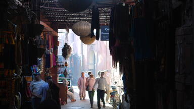
Nice, located on the Mediterranean, at the foot of the Alps, near the Italian border, in the Provence-Alpes-Côte d’Azur region, reflects the development of a city devoted to winter tourism, making the most of its mild climate and its coastal situation, between sea and mountains. From the mid-18th century, the site attracted growing numbers of aristocratic and upper-class families, mainly British, who developed the habit of spending their winters there. In 1832, Nice, then part of the Kingdom of Sardinia, set up the “Consiglio d’Ornato” which drew up a city planning scheme and architectural requirements designed to make the city attractive to foreigners. Thus, the “Camin dei Ingles”, a modest path which had been created along the coastline by British winter visitors in 1824, subsequently became the prestigious Promenade des Anglais. After the city was ceded to France in 1860, and thanks to its connection to the European rail network, an increasing number of winter visitors from all countries flocked to the city. This led to successive phases of development of new districts beyond the medieval old town. The diverse cultural influences of the winter visitors and the desire to make the most of the weather conditions and the coastal landscape have shaped the urban development and eclectic architectural styles of these districts, contributing to Nice’s reputation as a cosmopolitan winter resort.
Description is available under license CC-BY-SA IGO 3.0
Nice, la ville de la villégiature d’hiver de riviera
Nice, située sur la Méditerranée, au pied des Alpes près de la frontière italienne, en région Provence-Alpes-Côte d’Azur, témoigne de l’évolution d’une ville consacrée à la villégiature climatique hivernale, tirant parti de la douceur du climat et de sa situation de riviera, entre mer et montagnes. À partir du milieu du XVIIIe siècle, le site attira de plus en plus de familles aristocratiques et de la haute société, principalement britanniques, qui prirent l’habitude d’y passer leurs hivers. En 1832, Nice, appartenant alors au royaume de Piémont-Sardaigne, mit en place le « Consiglio d’Ornato », qui élabora un plan régulateur et des prescriptions architecturales visant à rendre la ville attrayante pour les étrangers. C’est ainsi que, le « Camin dei Ingles », modeste chemin qui avait été créé en 1824 par les hivernants britanniques le long du rivage, devint par la suite la prestigieuse Promenade des Anglais. Après que la ville fut cédée à la France en 1860, et grâce à son raccordement au réseau ferré européen, un nombre croissant d’hivernants de tous les pays, a afflué dans la ville, menant ainsi aux phases successives d’aménagement de nouveaux quartiers au-delà de la vieille ville médiévale. Les influences culturelles diverses exercées par les hivernants et le désir de tirer le meilleur parti des conditions climatiques et du paysage de riviera, ont façonné l’urbanisme et les styles architecturaux éclectiques de ces quartiers, contribuant à la renommée de Nice en tant que ville cosmopolite de villégiature d’hiver.
Description is available under license CC-BY-SA IGO 3.0
مدينة نيس، المنتجع الشتوي في منطقة الريفييرا
تقع مدينة نيس في منطقة البحر الأبيض المتوسط على مقربة من الحدود الإيطالية، وتقف شاهداً على تطوّر المنتجعات الشتوية بفضل ما تتسم به من مناخ معتدل، ناهيك عن موقعها المحاذي للبحر عند سفح جبال الألب. وأضحت مدينة نيس، منذ منتصف القرن الثامن عشر، وجهة تجذب أعداداً متزايدة من العائلات الأرستقراطية وأُسر الطبقة العليا، لا سيما الأُسر البريطانية، التي اعتادت قضاء فصول الشتاء فيها. واعتمدت مدينة نيس في عام 1832، حينما كانت جزءاً مما كان يُعرف باسم "مملكة بييمونتي سردينيا"، خطة حضرية تنظيمية هدفها جعل المدينة أكثر جاذبية للأجانب. وسرعان ما جرى توسيع مسار "كامين داي إنجليزي"، وهو طريق بعرض المترَين على طول ساحل البحر، ليصبح بمثابة منتزه مرموق يُعرف باسم "منتزه الإنجليز"، وذلك بعدما جرى التنازل عن المدينة لصالح فرنسا في عام 1860. وتوافدت أعداد متزايدة من الزوار الأجانب، لا سيما من روسيا، إلى المدينة خلال القرن التالي بحثاً عن أماكن لقضاء فصل الشتاء. وشهدت المنطقة جرّاء ذلك وعلى مراحل متعاقبة إنشاء مناطق جديدة على مقربة من المدينة التي تعود إلى القرون الوسطى. وبفعل الطيف الواسع من التأثيرات الثقافية لزوار الشتاء، مشفوعاً بالرغبة في تحقيق الاستفادة القصوى من الظروف المناخية والأجواء التي تعم المكان، تبلورت أشكال التخطيط الحضري والأنماط الانتقائية في العمارة في هذه المناطق، وسرعان ما حصدت المدينة شهرة كبيرة كمنتجع شتوي عالميّ.
source: UNESCO/CPE
Description is available under license CC-BY-SA IGO 3.0
里维埃拉旅游之都尼斯
地中海城市尼斯临近意大利边境,由于阿尔卑斯山脚下的温和气候和滨海地理位置,她见证了冬季气候型度假胜地的演变。从18世纪中叶开始,尼斯吸引了越来越多贵族和上流社会家庭前来越冬,他们主要来自英国。1832年,当时尚属萨丁尼亚王国的尼斯实施了一项旨在提高对外国人的吸引力的城市管理规划。此后不久,一条2米宽的滨海小道被扩建成享有盛誉的步行街,在1860年尼斯被割让给法国后,这条街被称为英国人步行大道。在接下来的一个世纪里,越来越多的来自其他国家,特别是俄罗斯的冬季居民涌入这座城市,推动了毗邻中世纪古城的新区域的持续发展。冬季居民的异域文化影响,以及充分利用当地气候条件和风景的愿望,塑造了该地区的城市规划和兼收并蓄的建筑风格,使这座城市成为知名的国际性冬季度假胜地。
source: UNESCO/CPE
Description is available under license CC-BY-SA IGO 3.0
Ницца, зимний курортный город Ривьеры
Средиземноморский город Ницца, расположенный недалеко от границы с Италией, является свидетелем эволюции зимнего климатического курорта в связи с мягким климатом города и его расположением у подножия Альп. С середины XVIII века Ницца привлекала все большее число аристократических семей и семей высшего сословия, в основном британцев, которые проводили здесь зимы. В 1832 году в Ницце, в то время входившей в состав Королевства Савойя-Пьемонт-Сардиния, был принят план городского развития, направленный на то, чтобы сделать город привлекательным для иностранцев. Вскоре после этого Camin dei Inglesi, скромная тропа шириной 2 метра вдоль морского берега, была расширена и превратилась в престижную набережную, известную как Английская набережная после того, как город был передан Франции в 1860 году. В течение следующего столетия в город из других стран стекалось всё большее число желающих провести здесь зиму, в частности гости из России, что привело к последовательным этапам развития новых районов рядом со старым средневековым городом. Многообразие культурных влияний зимних гостей города и желание максимально использовать климатические условия и ландшафт местности сформировали городское планирование и эклектичный архитектурный стиль этих районов, способствуя растущей славе города как космополитического зимнего курорта.
source: UNESCO/CPE
Description is available under license CC-BY-SA IGO 3.0
Niza, ciudad balnearia de invierno de la Riviera
Niza, situada en el mediterrénao, al pie de los Alpes, cerca de la frontera italiana, en la región de Provenza-Alpes Costa Azul, refleja el desarrollo de una ciudad dedicada al turismo invertal, sacando el máximo partido de su clima empleado y de su situación en la costa, entre el mar y la montaña. Desde mediados del siglo XVIII, Niza atrajo a un número cada vez mayor de familias aristocráticas y de clase alta, principalmente británicas, que acostumbraban a pasar allí los inviernos. En 1832, Niza, que entonces formaba parte del Reino de Cerdeña, creó el “Consiglio d’Ornato”, que desarrolló un plan regulador urbanístico destinado a hacerla atractiva para los extranjeros. Poco después, el “Camin dei Inglesi”, un modesto sendero de dos metros de ancho a lo largo de la orilla del mar creado por visitantes británicos en 1824, se amplió para convertirse en un prestigioso paseo marítimo, conocido como Promenade des Anglais (Paseo de los ingleses). Tras la cesión de la ciudad a Francia, en 1860, y gracias a su conexión con la red europea de ferrocarriles, comenzaron a llegar a la ciudad cada vez más visitantes invernales de todos los países. Ello condujo a sucesivas fases de desarrollo de nuevos distritos junto a la antigua ciudad medieval. Las diversas influencias culturales de los residentes invernales y el deseo de aprovechar al máximo las condiciones climáticas y el paisaje del lugar, configuraron la planificación urbana y los estilos arquitectónicos eclécticos de esos barrios, contribuyendo al renombre de la ciudad como estación invernal cosmopolita.
source: UNESCO/CPE
Description is available under license CC-BY-SA IGO 3.0

Outstanding Universal Value
Brief synthesis
The city of Nice bears witness to the evolution of the winter climatic resort (villégiature d’hiver), influenced by its location on the Mediterranean seashore and its proximity to the Alps. From the middle of the 18th century, the mild climate and picturesque setting of Nice attracted an increasing number of aristocratic families, mainly British, who took to spending their winters there. Over the next century, the growing number and social and cultural diversity of the winter residents became the main driving force behind the successive development phases of new areas of the city, situated next to the old medieval town. The diverse cultural influences of the winter residents and the desire to make the most of the climate conditions and scenery of the place, shaped the urban planning and architecture of those areas, contributing to the renown of the city as a cosmopolitan winter resort. Because it belonged to the Kingdom of Piedmont-Sardinia before 1860 and then to France, but above all the significant influx, from the outset, of winter visitors from Europe and then from all over the world, Nice was the crucible of many exchanges of influences, mainly in the field of architecture.
Indeed, vacationing led to the proactive implementation of specific forms of town planning which were deployed in several phases, first from the first two poles constituted by the "Vila Nova" and the "New Borough", then through the regulatory plans of the Consiglio d'Ornato as well as the plans drawn up in their continuity after 1860, then finally through the subdivision formula.
The property testifies to the evolution until 1939 of the search for an imaginary exoticism of the Riviera landscape. In the 18th century it was the aristocracy that undertook this search, but from 1860 it attracted the wealthy classes, giving way from 1920 to seaside activities and the summer season. In 1939, the outbreak of the Second World War interrupted the reception of tourists in Nice for almost a decade. After the war, the changes that had begun in the previous period continued, and the summer season definitively supplanted the winter season.
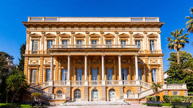
Criterion (ii): Nice, Winter Resort Town of the Riviera, represents an important example of the fusion of British, Italian, French, Russian and other cultural influences, resulting in a variety of architectural styles, designs and decorations of buildings that express its cosmopolitan character as a winter resort, especially in the 19th century, under the impetus of the Consiglio d'Ornato.
Fashionable styles in European capitals (neo-classicism, historicism, eclecticism, Belle-Époque, "neo-colonial", regionalist, Art-deco ...) were imported and reinterpreted in Nice, under the influence of sponsors, architects and craftsmen from different countries, who brought their know-how in decoration (stucco, sgraffito, painted friezes, rockeries, ceramics...).
Foreign contributions are also considerable in terms of the use and function of the facilities. Indeed, the development of winter resorts has led to the proliferation of three types of accommodation intended for foreigners: the travellers hotel, the villa and the seasonal holiday rentals. The amphitheatre setting facing the sea, the addition of vegetation (including many acclimatised species), and the walks - such as the Terrasse des Ponchettes and the Promenade des Anglais – encourage appreciation of the beauty of the site and the mild climate.
The sequenced street grid composed of north-south axes and perpendicular secondary roads favours the heliotropism of the facades and the perspectives towards the hills or the sea, by offering many facades facing south, while making room for different forms of vegetation: parks and public and private gardens, and separate plots and borders often planted with exotic species.
Integrity
The integrity of Nice, Winter Resort Town of the Riviera rests on attributes associated with its development as a winter resort and representation of the exchange of ideas between the mid-eighteenth century and the 1930s. The perimeter of the property testifies to the three periods which are the first founding phase of vacationing in Nice (1760-1860), the heyday of the "Winter Capital" (1860-1920), and the end of the period during which the reception function exclusively determined the destiny of the city (1920-1939).
The attributes of the property that convey the interchange of ideas and the fusion of British, Italian, French, Russian and other cultural influences are primarily the buildings and the diversity of architectural styles, building designs and decorations, exterior and interior. The traditional crafts and techniques that created these decorations, and are necessary for their preservation, are also considered as attributes. The uses and functions associated with these buildings also partly convey the value of the property. Since architecture cannot be separated from its context, the urban structure, landscaping, green spaces and promenades associated with this period are also important attributes, as well as viewpoints (lookouts, panoramas), the visual axes from the city to the large landscape, the relationship between built spaces and green spaces, and finally the relationships with the geographical setting (sea and mountain).
The urban configuration influenced by the various regulatory plans drawn up by the Consiglio d'Ornato has been preserved. In the second half of the 20th century, when Nice became mainly a summer destination, development pressures led to the densification of certain areas, notably on the hills of Cimiez and Mont-Boron, which nevertheless retained their architectural quality and a large number of their green spaces. Changes in the development of the road network and public spaces, depending on the evolution of modes of transport, have on the whole respected the pre-existing urban structure of the property.
The delimitation of the property makes it possible to ensure the complete representation of the attributes and to focus strictly on the sectors representative of the period between the mid-18th century and the end of the 1930s. The property does not suffer from elements disturbing its overall comprehension.
Authenticity
In terms of location and setting, the property faithfully conveys how the geography and topography of Nice were crucial elements influencing its development as a winter resort. Despite changes associated with the evolution of the city, which has become a summer destination, and despite the subsequent expansion of the city, the relationship with the sea and the surrounding mountains remains fundamentally the same. The extension (in length and width) of the Promenade des Anglais in the 1930s to facilitate road traffic, respected its function as a pedestrian promenade.
From the point of view of form and design, the urban configurations of the areas developed according to the regulatory plans drawn up by the Consiglio d'Ornato are on the whole intact. The areas of the property which were not influenced by such plans, but were largely developed on the basis of housing projects promoted by the private sector, nevertheless retained similar features such as wide tree-lined roads, low density plots and abundant vegetation.
The architectural typologies and construction features of the buildings, which marked the evolution of Nice as a winter resort, are still clearly visible and generally well preserved. The different architectural types -- neoclassical, eclectic or Art Deco -- depending on the period and often created by foreign promoters and architects, are to this day a distinctive feature of the city. It should be noted that most of the conservation and rehabilitation interventions are carried out respecting the original materials, colours and decorative elements. Most of the hotels, villas and apartment buildings retain their original function and continue to attract an international clientele.
Protection and management requirements
The protection of the property is established within the framework of French heritage protection legislation, in accordance with Article L. 612-1 of the Heritage Code, but also by the heritage protection measures of the metropolitan Local Urbanism Plan (PLU). The entire property was designated a Remarkable Heritage Site on 30 June 2021. This status imposes rules applicable to buildings and public spaces, and the obtaining of approval from the Architects of Buildings of France for each demolition or construction project.
The municipality has the main responsibility for the management of the property and its buffer zone. A special unit, the Nice World Heritage Mission, which reports directly to the mayor, has been created to coordinate the implementation of the management plan. A local World Heritage Commission has also been set up. This brings together representatives of municipal and metropolitan authorities, representatives of State services (for example the regional conservator of historic monuments and the Architects of Buildings of France) and other qualified professionals (scientific experts, representatives of citizens' associations). This Commission is responsible for validating the actions programme and monitoring the implementation of the management system. It meets once a year. A Steering Committee, with a very similar structure, but chaired by the municipality, is responsible for implementing the decisions of the local World Heritage Commission. This Committee meets two to three times a year. The monitoring of conservation work within the perimeter of the property is mainly carried out by the Architects of the Buildings of France and by the municipal services.
The delimitation of the buffer zone is determined by the visibility between the property and its direct landscape setting. Accordingly, the buffer zone is an extended area. The metropolitan PLU and its annexes determine the regulations for the buffer zone; their objective is to preserve the amphitheatre of hills that directly surround the property and the bay, in particular through the Development and Programming Orientation, known as “O. A. P. Collines”, which globally covers the upper part of the hills.
A management plan including the protection, conservation and enhancement measures to be implemented, is drawn up jointly by the State and the local authorities concerned, for the perimeter of this property and its buffer zone, then approved by the administrative authority. The Nice Management Plan should be updated in 2025 in order to assess its adequacy for the protection and management of the property and its buffer zone.
The maintenance and conservation of the property are based on French legislation, which facilitates the restoration of private historic heritage buildings, in particular by means of aid and tax incentives, the supervision of work projects, efforts to raise owners' awareness, and finally by defining rules for the insertion of contemporary creation into the historic urban fabric. In addition, the City of Nice has set up a multi-year investment programme for the public domain and heritage, under the control of the heritage services.
Mechanisms need to be put in place to facilitate coordination between the many actors having responsibilities for the management of the property, its buffer zone and the surrounding setting. It also appears necessary to complete the inventory in progress of the resort heritage, which will serve as a solid basis for conservation and management measures, as well as to identify the documentation relating to the interiors of the buildings and to put in place measures to ensure their protection, in particular with regard to the transformations which have made it possible to improve modern life and reception standards.

The Nomination files produced by the States Parties are published by the World Heritage Centre at its website and/or in working documents in order to ensure transparency, access to information and to facilitate the preparations of comparative analysis by other nominating States Parties.
The sole responsibility for the content of each Nomination file lies with the State Party concerned. The publication of the Nomination file does not imply the expression of any opinion whatsoever of the World Heritage Committee or of the Secretariat of UNESCO concerning the history or legal status of any country, territory, city or area or of its boundaries.