
Elexicon Energy and Quantum Spatial Canada Pilot Comprehensive Mobile Mapping Project
Elexicon Energy (Elexicon) was formed in April 2019 by the merger of Veridian Connections and Whitby Hydro Electric Corporation. Owned by five municipal shareholders, the electric utility provides energy services to more than 169,000 residential and business customers located in ten municipalities in east-central Ontario, Canada.
In 2019, Elexicon aimed to drive operational efficiencies by minimizing the amount of time required for boots-on-the-ground asset inspections, while eliminating the human error and reducing the field worker risks associated with manual surveys. To accomplish this, Elexicon’s Operations Technology & Innovation team embarked on a mobile mapping pilot project with Quantum Spatial Canada. Currently, Elexicon relies on manual surveys to evaluate assets for potential maintenance and analysis.
Spherical imagery and Lidar have been broadly adopted throughout the utility industry. The technologies have proved particularly useful in power transmission projects, as airborne sensors are able to efficiently collect data over lengthy transmission corridors; however, they are less commonly used by Canada’s energy distributors. Elexicon’s Operations Technology & Innovation team initiated the project with Quantum Spatial Canada, using mobile-mounted sensors instead of airplanes to increase the pulse density and accuracy achieved during acquisition. The core goal of the pilot project was to create an accurate inventory of the utility’s assets, enhance existing GIS systems, and optimize vegetation management.
In addition to simplifying Elexicon’s vegetation and asset management programs, the project offered the opportunity to investigate additional use cases for new Lidar data sets and share them with nearby agencies and organizations, potentially even resulting in additional cost-sharing opportunities. Quantum Spatial’s inSITE, an online platform which integrates remotely sensed data with existing utility systems, provided an intuitive tool for Elexicon to automate work management and track operations in real time.
Detailed Targets and New Use Cases
Quantum Spatial conducted a mobile Lidar survey of a 19-square kilometer sample area of Elexicon’s system in Ajax, Ontario. The acquisition took place over a three-day period in late 2019 in leaf-off conditions with snow present. Elexicon provided Quantum Spatial with GIS data listing all 1,938 poles within the service area sample.
The acquisition team chose pulse rate and ground speed parameters to ensure that the collected data would meet project accuracy and resolution specifications while demanding as little survey time as possible. The Trimble MX9 system maintained a minimum of 20 pulses per square meter over terrestrial surfaces, ensuring accuracy and feature definition. The system uses a 30-megapixel camera to capture 360 degrees of image data surrounding the vehicle, and the MX9’s backward-facing Lidar sensors are capable of covering roadside assets up to 50 meters away.
Elexicon required high levels of accuracy for the captured Lidar data, including absolute accuracy of three–six centimeters and relative accuracy of at least two centimeters for the development of 2D CAD systems and 3D CAD engineering models. In addition to utility assets, Elexicon required a catalog of all non-utility assets in the sample area such as fire hydrants, traffic lights, and sewer grates. The Lidar survey also collected data on potholes in the sample area, including their dimensions.
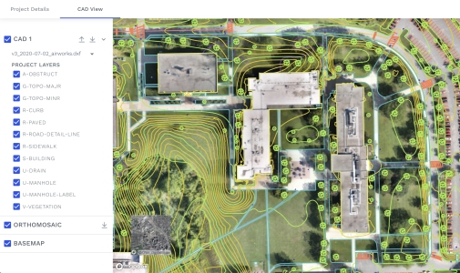
Following acquisition, Quantum Spatial employed a series of processing tasks to calibrate the data. These techniques included GNSS positioning, relative accuracy testing, calculation of laser point position, kinematic corrections, classification of ground and non-ground points, and statistical accuracy assessments of non-vegetated vertical accuracy. Quantum Spatial’s inSITE platform was used to host point cloud, spherical imagery, and distribution vector data.
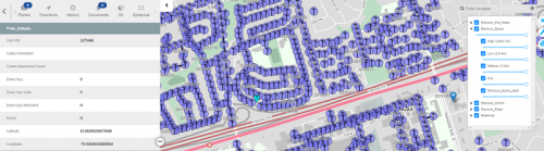
The Elexicon pilot project offered an opportunity to employ one of Quantum Spatial’s newest technologies, the inSITE Pole Manager. The collected data was loaded into the platform, enabling Elexicon to access deliverables online and share with relevant team members. The Pole Manager hosts a 2D map representation of the poles, spans, and potholes, as well as information on pole assets, spherical imagery, and a 3D Lidar point cloud. The full-function solution offers real-time risk assessments, enabling utilities to create work orders, forecast resources, dispatch assignments, and track progress from a single platform. The platform allows utilities to conduct full load analysis on 10,000 poles in two months, reducing the need for manual surveys and eliminating the potential for human error.
Custom Deliverables and Lessons Learned
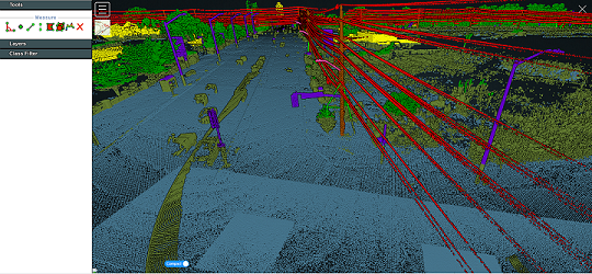
Once the data was acquired, Quantum Spatial provided Elexicon with a suite of custom analytic reports to help improve utility operations and inform business decisions. For example, as part of the pilot, Quantum Spatial conducted an encroachment analysis of vegetation within the survey area, categorizing encroachments according to their proximity to wires and relative position to the wire. The analysis used the 3D models created from the Lidar sample data, and encroachments were categorized as High Priority (within 3 meters of a wire), Medium Priority (between 3 to 3.5 meters), or Low Priority (between 3.5 to 4 meters).
The pilot project also included a full audit of utility and non-utility assets which could be used for future construction and data acquisition projects without needing to deploy additional assets . Quantum Spatial created a suite of Shapefile reports, identifying road crossings in the sample area and their height; poles with third-party attachments and details of the attachments; Elexicon pole identifiers and their centrepoint as captured in the Lidar data; and Elexicon poles with cable risers on them. An additional report identified discrepancies between guy wires in the captured Lidar data and guy wires in Elexicon’s GIS. These tools enabled Elexicon to evaluate its assets within the service area and plan appropriate maintenance without the time-consuming process of conducting manual inspections.
“Our mobile mapping pilot project with Quantum Spatial Canada demonstrated the potential applicability of mobile Lidar to our distribution network,” said Falguni Shah, Vice President, Technology and Innovation at Elexicon Energy. “The deliverables from Quantum Spatial have showed potential to improve our service and operational efficiencies, and we hope to continue our work together in the future as we drive further innovations in energy distribution.”
The pilot also set the stage for future projects, including the development of a machine learning solution to automatically differentiate porcelain and polymer insulators. While higher resolution was required to fully realize this use case, the pilot analytics work completed through this pilot supports the future development of this solution.
The pilot project demonstrated the value of conducting Lidar surveys for energy distribution networks, potentially delivering similar operational efficiencies as are commonplace in power transmission projects. The ambitious, forward-thinking mindset of Elexicon’s Operations Technology & Innovation team showcased how precise Lidar datasets enrich information currently available in GIS systems, quickly establish an accurate and highly detailed asset inventory, and illustrate how a single-pass of mobile Lidar collection leverages this advanced technology for collaboration and cost-sharing opportunities with local organizations and agencies.